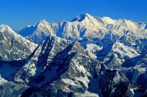
The Himalaya – Earth’s mightiest mountain range – stands today as a breathtaking testament to the power of geological forces. Towering peaks like Mount Everest and Kanchenjunga pierce the skies, glaciers slowly carve the valleys, and rivers born in their icy hearts nurture billions of people. But these mountains weren’t always here. In fact, the Himalaya are among the youngest geological features on Earth. Their story, however, stretches back hundreds of millions of years and begins not in the highlands, but in the depths of an ancient sea.
This is the story of the Himalaya’s birth – a narrative that unfolds over vast timescales, shaped by the drift of continents, the clash of tectonic plates, and the slow but unrelenting forces of uplift, erosion, and transformation. Let’s journey through time to trace the geological evolution of the Himalaya.
An Ancient World: Before the Himalaya
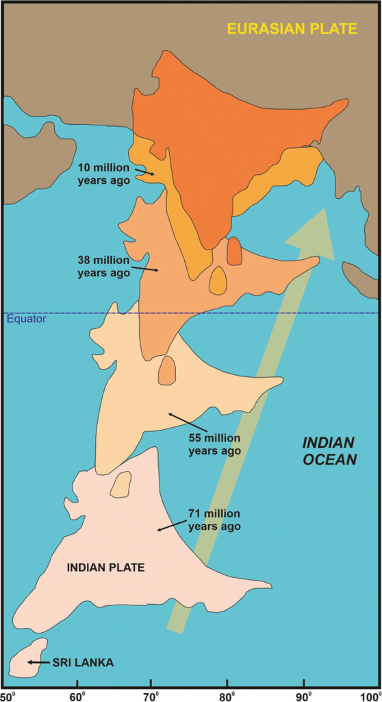
To understand how the Himalaya formed, we need to go back more than 500 million years, to a time when Earth looked completely different. What is now the Indian subcontinent was once part of a massive southern supercontinent called Gondwana. This landmass included not only India, but also Africa, Australia, South America, and Antarctica.
Back then, the region that would become the Himalaya was submerged under the Tethys Ocean, a vast and ancient sea that separated Gondwana from another supercontinent to the north – Laurasia, which included modern-day Asia and Europe. Over millions of years, sediments accumulated at the bottom of this ocean, forming thick layers of sandstone, shale, limestone, and marine fossils.
The Great Drift: India on the Move
Around 180 million years ago, during the Jurassic period, Gondwana began to break apart. Driven by powerful convection currents deep within the Earth’s mantle, the Indian Plate broke off and started its long journey northward.
This was no leisurely drift. The Indian Plate moved with remarkable speed – about 15–20 cm per year, one of the fastest plate movements ever recorded in Earth’s history. Over tens of millions of years, it closed the gap between itself and the Eurasian Plate, swallowing the Tethys Ocean in the process.
The sediments on the ocean floor, along with the oceanic crust itself, were caught in the middle. They were compressed, folded, and thrust upward, setting the stage for a continental collision of epic proportions.
The Collision That Shaped a Continent
Roughly 50 million years ago, during the Eocene epoch, the Indian Plate slammed into the Eurasian Plate. This was no ordinary impact. Unlike oceanic crust, which can be forced downward into the mantle, continental crust is buoyant and resists subduction. So when India and Eurasia collided, neither sank.
Instead, the crust buckled and thickened. The sediments of the Tethys Ocean were squeezed and uplifted. The northern edge of the Indian Plate began to dive beneath the southern edge of the Eurasian Plate, pushing layers of rock skyward. This marked the birth of the Himalaya.
From that moment on, the region became a dynamic zone of mountain-building – a process geologists call orogeny. And it hasn’t stopped since.
Rising Giants: The Growing Himalaya
What followed was a dramatic geological upheaval. The force of the Indian Plate’s continued push under Eurasia caused the crust to double in thickness in some areas. Layers of rock that had once lain at the bottom of the sea now rose to dizzying heights, becoming some of the highest mountains on Earth.
The Himalaya are made up of several parallel geological belts, each with its own story:
- The Tethys Himalaya, formed from marine sediments, contain rich fossils and give us clues about life in the ancient Tethys Sea.
- The Greater Himalaya, with high-grade metamorphic rocks, represent deeply buried crustal materials that were later uplifted.
- The Lesser Himalaya consists of older sedimentary and metamorphic rocks, folded and thrust over one another.
- The Siwalik Hills, the southernmost part of the range, are composed of much younger rocks – the eroded debris from the rising mountains.
These belts are separated by major faults, or thrusts, such as the Main Central Thrust (MCT), the Main Boundary Thrust (MBT), and the Main Frontal Thrust (MFT) – powerful zones where rocks have been shoved over each other for tens of kilometers.
Geological Age-wise Evolution of the Himalaya
| Geological Era/Period | Approximate Age (Million Years Ago – Ma) | Major Events in Himalayan Evolution |
|---|---|---|
| Precambrian (Archean–Proterozoic) | >2500 to ~540 Ma | Formation of the Indian Shield and basement rocks (e.g., Bundelkhand, Aravalli). These form the ancient continental core of the Indian Plate. |
| Cambrian to Permian (Paleozoic Era) | ~540–250 Ma | Sedimentation in the Tethys Sea; deposition of marine sediments that would later become the Tethys Himalaya. The Indian Plate was still part of Gondwana. |
| Triassic to Jurassic (Mesozoic Era) | ~250–145 Ma | Continued sedimentation; initiation of rifting and northward drift of the Indian Plate after Gondwana breakup. |
| Cretaceous Period | ~145–66 Ma | Rapid northward movement of the Indian Plate across the Tethys Ocean. Oceanic crust between India and Eurasia begins to subduct beneath Eurasia. |
| Paleocene to Eocene (Early Cenozoic Era) | ~66–34 Ma | Main collision phase begins (~55–50 Ma). Uplift of the Tethyan sediments; initial rise of proto-Himalaya. Formation of the Main Central Thrust (MCT) begins. |
| Oligocene to Miocene | ~34–5 Ma | Continued convergence; formation of Greater and Lesser Himalaya through crustal thickening. Development of the Main Boundary Thrust (MBT) and Main Frontal Thrust (MFT). Formation of Siwalik sediments from erosion of rising mountains. |
| Pliocene to Quaternary (Modern Era) | ~5 Ma–Present | Rapid uplift and intense erosion. Formation of current Himalayan topography. Frequent earthquakes. Deposition of Siwalik and Indo-Gangetic Plain sediments. Himalayan glaciers grow and retreat cyclically. Active mountain-building continues today. |
A Mountain in Motion: The Himalaya Today
While the Himalaya may look permanent and immovable, they are anything but. The Indian Plate is still pushing northward at a rate of around 5 cm per year. As a result, the Himalaya continue to rise – albeit very slowly, about 5 mm per year on average.
This ongoing convergence also makes the region one of the most seismically active on the planet. The energy generated by the compressing plates builds up over time and is released in sudden jolts – earthquakes. Devastating events like the 2005 Kashmir earthquake and the 2015 Nepal earthquake are stark reminders of this reality.
The Himalaya are still being shaped and reshaped – not just by tectonics, but also by erosion. Rivers, glaciers, wind, and rain are constantly wearing them down. The balance between uplift and erosion is what gives the Himalaya their dramatic, rugged topography.
Glaciers, Rivers, and Life-Giving Sediments
The Himalaya aren’t just a geological marvel – they are the source of life for much of Asia. The immense glaciers that sit atop their peaks are often called the “Third Pole” because they hold more freshwater than anywhere else except the Arctic and Antarctic.
These glaciers feed major rivers like the Ganga, Yamuna, Brahmaputra, Indus, and Sutlej. These rivers carry the eroded sediments of the Himalaya downstream, building the fertile Indo-Gangetic Plain – one of the most densely populated and agriculturally productive regions on Earth.
Every monsoon season, rains fall on the slopes of the Himalaya, swelling these rivers and spreading life-giving silt across the plains. In this way, the Himalaya have shaped not just the landscape, but also the economies and cultures of the entire subcontinent.
A Living Record: Fossils, Rocks, and Time
As geologists explore the Himalaya, they uncover more than just rocks – they find records of Earth’s past. Fossils of trilobites and ammonites found in the Tethys Himalaya tell us about ancient marine environments. High-grade metamorphic rocks in the Greater Himalaya reveal how deep within the Earth these rocks were buried and how much pressure and heat they endured before being exhumed.
By studying isotopes, fossils, and structural deformations, scientists can reconstruct the timeline of the Himalaya’s evolution with surprising precision. These rocks hold secrets not only about the mountains themselves, but also about global climate shifts, sea level changes, and even the timing of monsoon intensification.
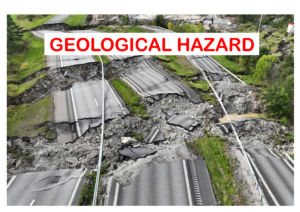
Fragile Giants: Hazards and Human Impact
The Himalaya may seem indomitable, but they are incredibly fragile. Landslides, glacial lake outburst floods (GLOFs), and earthquakes pose constant threats to communities in the region.
Human activity has amplified these risks. Road construction, deforestation, hydropower development, and unchecked tourism have destabilized slopes and disrupted ecological balances. The 2021 Chamoli disaster in Uttarakhand, triggered by a glacier break and landslide, highlighted the dangerous intersection of climate change and human interference.
Climate change is perhaps the greatest threat. Himalayan glaciers are retreating at alarming rates, affecting water supply and increasing the risk of natural disasters. The mountains are warming faster than the global average, altering ecosystems and threatening the unique biodiversity of the region.