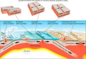
Drainage pattern refers to the natural arrangement and distribution of streams and rivers in a region, showing how water flows across the land surface. It is an important geomorphic feature because it is strongly controlled by factors such as slope, relief, climate, and most importantly the underlying geology. Different rock types and geological structures like faults, joints, folds, and bedding planes influence the direction, shape, and density of drainage networks. Therefore, studying drainage patterns helps geologists understand subsurface lithology, structural trends, and landscape evolution, making it a valuable tool in geological mapping and mineral exploration.
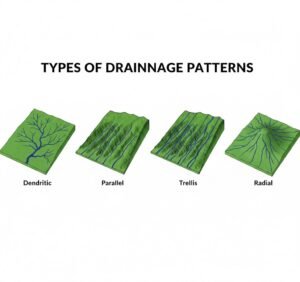
Types of drainage pattern
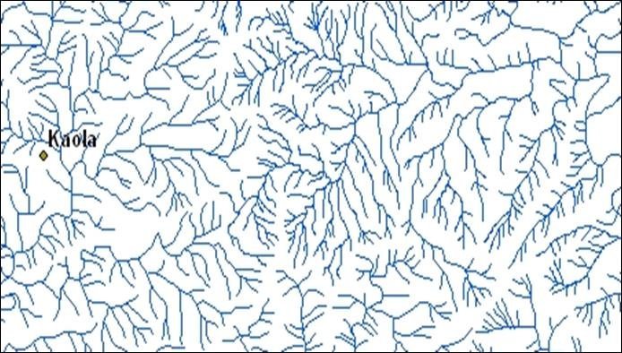
Dendritic Drainage Pattern
The dendritic drainage pattern is the most common type. It looks like the branches of a tree. The tributaries join the main stream at acute angles. The streams spread in all directions without a fixed control. This pattern forms when the underlying rock is uniform and homogeneous. It means the rock has almost the same resistance everywhere. Since there is no major structural control, water simply flows naturally along the slope.
Dendritic drainage is commonly found in areas of:
- Granite
- Sandstone
- Basalt flows
- Flat lying sedimentary rocks
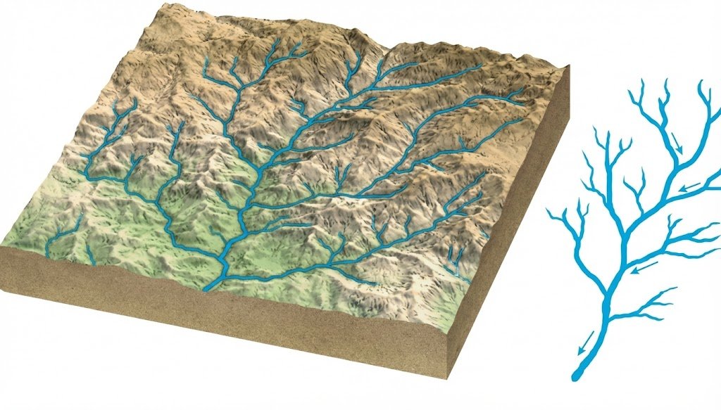
In geology, dendritic drainage indicates that the area has no major folding or faulting influence. It suggests stable and uniform bedrock.
Sub-Dendritic Drainage Pattern
Sometimes dendritic drainage is not perfectly developed. The streams may show slight alignment in one direction. This is called sub-dendritic drainage. It develops when the rock is mostly uniform but contains minor joints, fractures, or slight structural trends. This pattern is common in areas where granite is jointed or where sedimentary rocks have minor bedding influence.
Sub-dendritic drainage is important because it indicates the beginning of structural control.
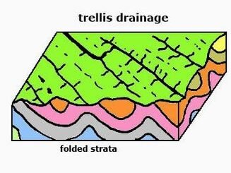
Trellis Drainage Pattern
The trellis drainage pattern looks like a garden fence. The main streams flow in one direction, and tributaries join them almost at right angles. This pattern is very systematic and organized. Trellis drainage forms in regions where rocks are folded or tilted. It is strongly controlled by alternating hard and soft rocks. The main streams usually flow through softer rocks, while tributaries cut through hard ridges.
This pattern is common in:
- Folded sedimentary terrains
- Alternating shale and sandstone belts
- Metamorphic belts with strong foliation
- Himalayan fold systems
Trellis drainage is a strong indicator of folding, structural valleys, and parallel ridges. It is very useful in structural geology.
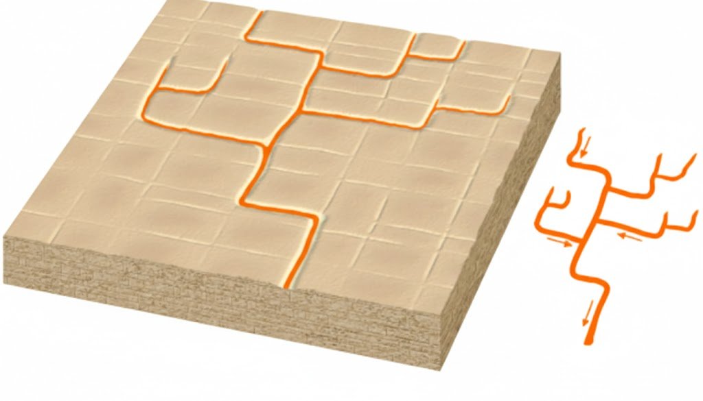
Rectangular Drainage Pattern
The rectangular drainage pattern is easy to identify. Streams show sharp bends, and many channels meet at near 90° angles. The drainage looks like a blocky grid. This pattern develops due to jointing and faulting. Water follows the cracks and fractures. When the fractures intersect at right angles, the drainage also turns sharply.
Rectangular drainage is common in:
- Granite and gneiss terrains with joints
- Faulted plateaus
- Areas affected by tectonic stress
In geological interpretation, rectangular drainage strongly suggests the presence of faults, joints, and fracture systems. These zones can also be favorable for groundwater and mineralization.
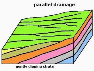
Parallel Drainage Pattern
In the parallel drainage pattern, streams flow almost parallel to each other. Tributaries are few, and the channels show a strong direction. This pattern develops on steep slopes or where rocks are tilted strongly. It forms when water rapidly flows downhill without much branching.
Parallel drainage is common in:
- Escarpments
- Cuesta landscapes
- Steep hill slopes
- Highly dipping sedimentary beds
Geologically, parallel drainage indicates strong slope control and structural tilt. It also suggests active erosion.
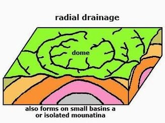
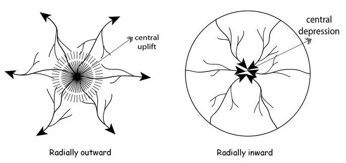
Radial Drainage Pattern
The radial drainage pattern is one of the most beautiful types. Here streams flow outward from a central high point, like spokes of a wheel. This pattern forms around volcanic cones, domes, and isolated hills. The central part is the highest, so water moves outward in all directions.
Radial drainage is found in:
- Volcanic mountains
- Igneous domes
- Structural domes
In geology, radial drainage is a clear clue for volcanic landforms or dome-shaped uplifts.
Centripetal Drainage Pattern
The opposite of radial is centripetal drainage. In this case, streams flow inward toward a central depression or basin.This pattern forms in closed basins, craters, or structural depressions. It is common in arid areas where drainage ends in lakes or salt pans.
Centripetal drainage occurs in:
- Rift valleys
- Structural basins
- Playas and desert lakes
This pattern indicates basin formation and subsidence zones.
Annular Drainage Pattern
The annular drainage pattern looks like rings. Streams flow in circular paths around a central structure. This pattern forms when there are concentric rock bands of varying hardness. It is often linked to domes or basins where erosion exposes circular layers.
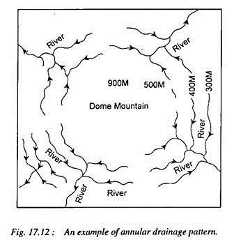
Annular drainage is common in:
- Dome structures
- Basin structures
- Circular folded regions
Geologically, annular drainage is a strong indicator of structural doming or basin formation.
Angular Drainage Pattern
The angular drainage pattern is similar to rectangular but less regular. Streams bend sharply at angles, but not always at perfect 90°.
This occurs in areas with fractured rocks where joint patterns are irregular. It is common in crystalline terrains and tectonically disturbed zones.
Angular drainage suggests strong tectonic influence and brittle deformation.
Deranged Drainage Pattern
The deranged drainage pattern looks messy and disorganized. Streams do not form a proper network. Many lakes, swamps, and irregular channels are present. This pattern develops in newly formed landscapes where drainage has not matured. It is common in areas affected by glaciation or landslides.
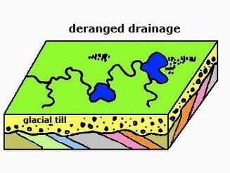
Deranged drainage is found in:
- Glacial terrains
- Recently uplifted land
- Landslide zones
In geology, it indicates young geomorphic development and unstable landforms.
Barbed Drainage Pattern
The barbed drainage pattern is unusual. Tributaries join the main river in the opposite direction, creating a hooked appearance. This pattern often forms due to river capture or tectonic tilting. It is seen where a river changes its direction due to structural disturbance.
Barbed drainage is an important clue for:
- Stream piracy
- Neotectonic uplift
- River diversion
This pattern is very useful in tectonic geomorphology.
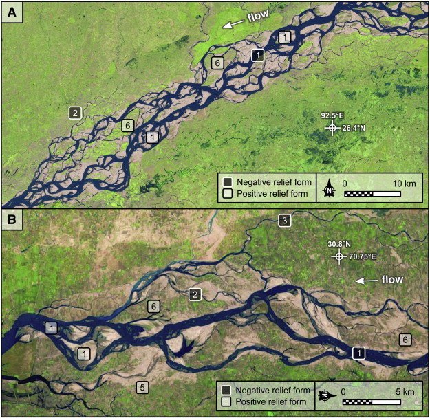
Anastomosing Drainage Pattern
In an anastomosing drainage pattern, rivers split into multiple channels and then join again. It forms a braided-like network but with stable banks.This occurs in low-gradient floodplains where fine sediments dominate.
This pattern is common in:
- Delta plains
- Floodplain regions
- Alluvial basins
Geologically, it indicates active sedimentation and flat terrain.
Braided Drainage Pattern
Braided drainage forms when a river divides into many small channels separated by sand bars and gravel bars. It looks like a braid. This pattern develops when sediment load is very high and water flow changes frequently. It is common in glacial rivers and Himalayan rivers.
Braided rivers are linked to:
- High sediment supply
- Steep slopes
- Unstable channels
Braided drainage indicates high energy deposition zones.
| Quick Key Points |
| Dendritic = uniform rocks like granite Trellis = folded terrain and alternating hard-soft rocks Rectangular = joints and faults Parallel = steep slope or tilted strata Radial = volcanic cone or dome Centripetal = basin or depression Annular = circular, folded or domal structures Deranged = young terrain or glacial effect Braided = high sediment load rivers |