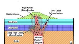
Geology is, in many ways, a detective story written in stone. The clues that tell us how the Earth was formed, evolved, and continues to change are locked within rocks, minerals, soils, and sediments. But how do geologists uncover these stories? It all begins with a fundamental skill: geological sampling. While it might sound mundane at first glance, geological sampling is the very foundation of everything from mineral exploration to understanding Earth’s history. This article explores the importance, principles, and various techniques of geological sampling in a relatable, scientific manner.
What is geological sampling?
At its core, geological sampling is the process of collecting materials from the Earth’s surface or subsurface to study their properties, composition, and distribution. These materials could include:
- Rocks and minerals
- Soils and sediments
- Water and gas (in hydrogeology and volcanology)
- Fossils and organic matter
Why do we do it? Because laboratory analyses depend on representative, accurate, and well-documented samples. Whether it’s determining the economic potential of a mineral deposit or tracing the source of a landslide, quality sampling is the bedrock of good geological science.
Principles of sampling
Good sampling isn’t random. It’s based on scientific logic, observation, and consistency. There are a few golden rules geologists follow:
- Representativeness: The sample must reflect the larger geological unit it came from.
- Systematic Collection: Sampling should follow a plan—grids, traverses, or stratigraphic layers.
- Avoiding Contamination: Tools and containers must be clean, and different sample types kept separate.
- Documentation: Every sample needs a label, GPS location, description, and field notes.
Sampling may look simple in the field, but the integrity of a multi-crore mining project or a national groundwater survey can rest on how a few grams of rock were collected.
Types of geological sampling techniques
Geological sampling techniques are tailored to the type of material being studied and the objectives of the project. Below are the most common techniques used by geologists in the field.
Grab Sampling:
Grab sampling is a quick and simple method of collecting a single or a few random samples from a specific location, commonly used in geological and geochemical surveys. It involves taking material—such as rock, soil, or water—without any systematic approach, assuming it represents the area of interest. This method is useful in preliminary exploration to detect the presence of mineralization or contamination. It is cost-effective and easy to carry out, especially in remote or hard-to-reach areas. However, grab samples may not accurately represent the average composition of the deposit due to natural variability and potential sampling bias. Therefore, while valuable in the early stages of exploration, it is generally followed by more systematic methods like channel or composite sampling for reliable results.
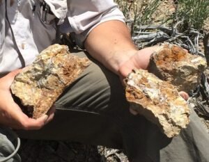
Chip Sampling:
Chip sampling is a method used in geological exploration where small, representative pieces (or “chips”) of rock are collected along a specified line or surface, such as a vein, outcrop, or trench. The chips are taken at regular intervals using a hammer or chisel, often across the width of a mineralized zone. This technique provides a more reliable and representative sample than grab sampling, as it covers a specific length or area systematically. Chip sampling is especially useful for determining the grade and continuity of mineralization across exposed surfaces. While more labor-intensive than grab sampling, it helps reduce sampling bias and is often used in combination with mapping to guide further exploration or drilling.
Channel Sampling:
Channel sampling is a systematic and quantitative method of sampling used in geological exploration to assess the grade and continuity of mineralization across a rock face, vein, or ore body. In this method, a narrow, continuous groove or channel is cut across the exposed surface—usually with a hammer and chisel, or mechanical tools like rock saws—and small, uniform chips of rock are collected along its entire length.
Unlike grab or chip sampling, channel sampling ensures that all portions of the sampled section are equally represented, making it a more reliable technique for estimating ore grades. It is especially useful in trenches, underground workings, or exposed mineralized zones. Channel samples are typically taken perpendicular to the strike of the mineralized zone to best represent the true width and grade. Though more time-consuming and labor-intensive, it provides better accuracy for resource evaluation and is often used before planning detailed drilling programs.
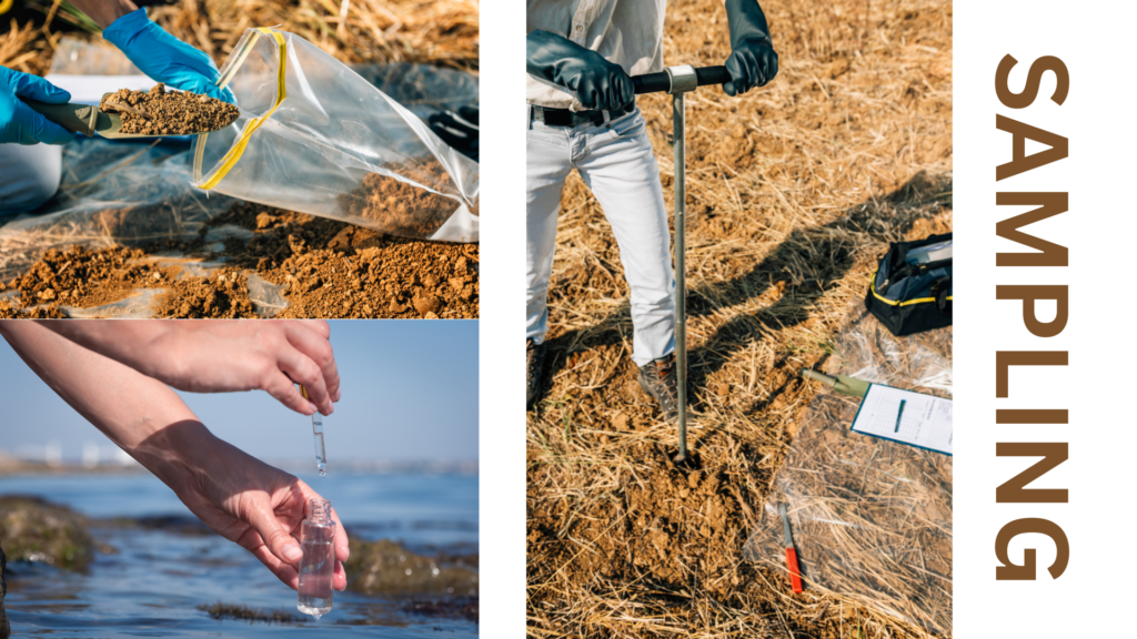
Soil Sampling:
Soil sampling is a fundamental technique in geological and geochemical exploration used to assess the presence and distribution of mineralization beneath the surface. It involves the systematic collection of soil from the upper few centimeters to around a meter deep, depending on the survey objective and terrain. The primary goal is to analyze the geochemical signature of the soil to detect trace elements or anomalies that may indicate underlying mineral deposits such as gold, copper, uranium, or other economically important minerals.
Soil samples are usually collected along grid lines or traverses at regular intervals to ensure spatial coverage and consistency. Factors like topography, soil type, vegetation, and weathering are considered while interpreting results, as they can influence the mobility and concentration of elements. This method is particularly effective in areas with shallow overburden where bedrock is not exposed. Soil sampling is cost-effective and useful in early-stage exploration, guiding more detailed investigations such as trenching, drilling, or geophysical surveys.
Core Drilling and Sampling:
In exploration and engineering geology, core drilling is the gold standard. A cylindrical drill extracts a continuous core of rock from deep underground.
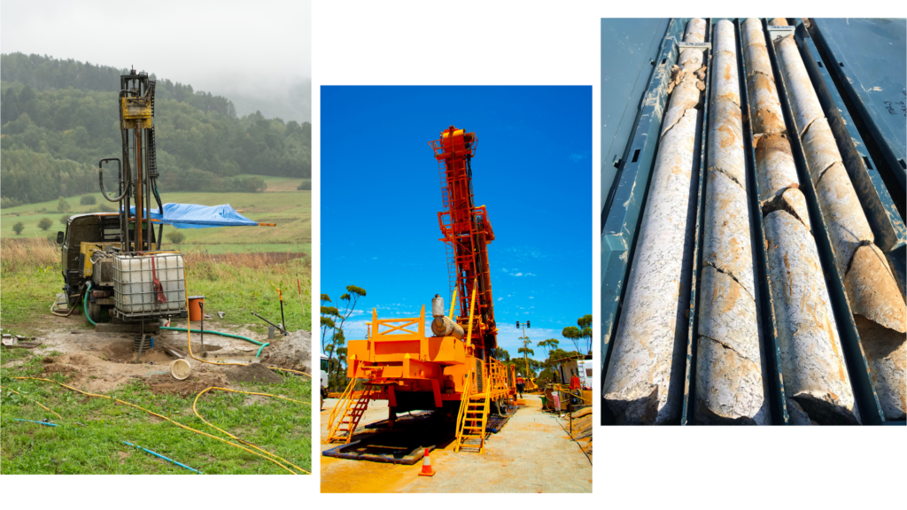
- Use Case: Mining exploration, geological mapping, structural analysis.
- Core Logging: After retrieval, the core is logged, photographed, split, and analyzed.
- Challenge: Expensive, but gives 3D insight into subsurface geology.
This method provides a literal timeline of the Earth’s subsurface, like reading a vertical scroll of geologic history.
Trench and Pit Sampling:
Trench and pit sampling is a geological exploration technique used to collect samples directly from the exposed bedrock or mineralized zones by excavating shallow pits or trenches. This method allows geologists to examine and sample subsurface materials in areas where natural outcrops are scarce or absent. Trenches are typically dug across the strike of the mineralized zone to expose the true width and structure, while pits are dug vertically or near mineralized showings to access and observe the lithology and alteration features.
The exposed faces of trenches and pits provide an opportunity for detailed geological mapping, structural observations, and systematic sampling such as chip or channel sampling. This method is particularly useful in later stages of exploration when targets identified through soil sampling, geophysical surveys, or remote sensing need to be verified and evaluated in detail. While trenching and pitting can be labor-intensive and may require environmental permissions, they offer a relatively low-cost and effective means to assess mineralization continuity, grade, and surface geometry before committing to drilling programs.
Stream Sediment Sampling:
Stream sediment sampling is a widely used geochemical exploration method that involves collecting sediments from active stream or river beds to detect and trace the source of mineralization in a drainage basin. As water flows over bedrock and through soil, it transports and deposits fine-grained sediments that may contain trace amounts of metals derived from upstream sources. By analyzing these sediments, geologists can identify geochemical anomalies that point to potential mineral deposits, even in areas with no visible outcrops.
Samples are usually collected from the active part of the stream, focusing on fine materials like silt, clay, or pan concentrates from behind boulders or inside meanders where sediments naturally accumulate. The sampling is done at regular intervals along drainage lines, and each site is carefully recorded with GPS and field notes. This technique is especially effective in regional reconnaissance surveys, as it covers large areas quickly and at relatively low cost. It helps in narrowing down prospective zones, which can then be followed up with soil sampling, trenching, or drilling for detailed evaluation.
Preservation and Documentation
Once collected, samples must be:
- Properly labeled with sample ID, coordinates, date, and type.
- Sealed in bags or boxes, especially for geochemical analysis.
- Logged in a field notebook or digital app with sketches and observations.
Preserving context is just as important as the sample itself. A mislabelled or misplaced sample could render lab results meaningless.
Question Practice
1. What is grab sampling?
Grab sampling is the collection of a single rock or soil sample from a specific location without a defined pattern. It provides quick insight into mineral presence but may not represent the overall deposit.
2. When is grab sampling most useful?
It is most useful during early-stage reconnaissance surveys when geologists need rapid indications of mineralization across a large area.
3. What is chip sampling?
Chip sampling involves collecting small, broken rock fragments at regular intervals across an outcrop, vein, or trench face to represent a specific section.
4. How does chip sampling improve over grab sampling?
Chip sampling is more systematic and reduces bias by covering a defined area or width of mineralization.
5. What is channel sampling?
Channel sampling is a method where a continuous groove or channel is cut across a rock face, and uniform material is collected along it for chemical analysis.
6. Why is channel sampling considered reliable?
Because it provides continuous and representative samples across a mineralized zone, allowing accurate estimation of grade and thickness.
7. What is the purpose of soil sampling in exploration?
Soil sampling detects geochemical anomalies in near-surface soils, helping to identify hidden mineralization without needing rock outcrops.
8. How are soil samples usually collected?
They are collected from a consistent depth using augers or shovels, often along grid lines or transects.
9. What is stream sediment sampling?
Stream sediment sampling involves collecting fine sediments from river or stream beds to identify mineral anomalies from upstream sources.
10. Why is stream sediment sampling valuable in regional surveys?
It can cover large areas quickly and detect mineral dispersion from source rocks not directly exposed on the surface.
11. What is trench sampling?
Trench sampling involves excavating a shallow linear trench across a mineralized zone to expose bedrock and collect systematic samples.
12. How does trench sampling support exploration?
It allows detailed mapping and sampling of mineralized zones, especially where outcrops are limited or absent.
13. What is pit sampling and where is it used?
Pit sampling involves digging vertical or semi-vertical holes to expose sub-surface geology, commonly used in soil-covered or flat terrains.
14. What is composite sampling?
Composite sampling is the process of combining several individual samples into one to obtain an average result over a larger area or interval.
15. Why is choosing the correct sampling method important?
The right sampling method ensures accurate, representative data, reduces bias, and guides effective exploration decisions and resource estimation.