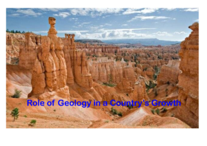
Introduction
Once associated with field notebooks, rock hammers, and sketches of fossils, geology has experienced a quiet transformation. These days, soil samples and strata are just as important as satellites, sensors, and supercomputers. Geology has adopted state-of-the-art technologies in recent decades, and more so in the last decade, becoming a multidisciplinary, data-driven science. Today, geology lies at the fascinating intersection of history and technology, whether it be in the form of earthquake prediction, groundwater monitoring, or the search for vital minerals. In this article the recent advancement are discussed in different field of geology.
1. Remote sensing and satellite imagery
The utilization of satellite imaging and remote sensing is one of the most revolutionary developments in contemporary geology. With the help of organizations like NASA, ISRO, and ESA, high-resolution satellite data is now accessible for previously unheard-of levels of surface analysis. Geologists can now locate fault lines, lithological boundaries, and mineral fingerprints from space thanks to hyperspectral and multispectral imagery.
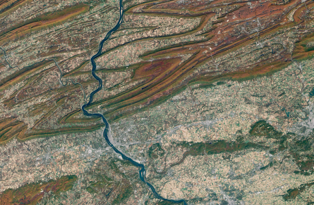
For geological mapping and mineral development, remote sensing has proven invaluable in areas where field access is challenging, such as deserts, deep forests, or politically sensitive zones. By providing real-time data on volcanoes, landslides, glacier movement, and erosion trends, these tools aid in disaster preparedness and research.
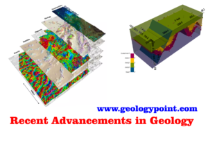
2. GIS and 3D geological modeling
One of the most significant advancements in modern geology is the use of remote sensing and satellite imaging. High-resolution satellite data is now available for unprecedented levels of surface investigation thanks to agencies like NASA, ISRO, and ESA. Thanks to hyperspectral and multispectral photography, geologists can now identify mineral fingerprints, fault lines, and lithological boundaries from space.
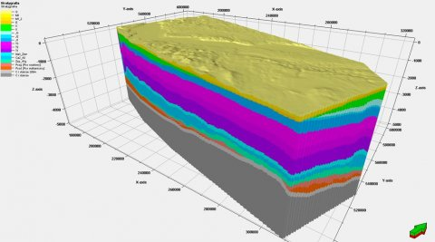
In regions like deep forests, deserts, or politically sensitive places where field access is difficult, remote sensing has proven crucial for geological mapping and mineral exploitation. These tools support disaster planning and study by offering real-time data on landslides, volcanoes, glacier movement, and erosion trends.
3. Artificial intelligence and machine learning
The application of machine learning (ML) and artificial intelligence (AI) to geology has created previously unimaginable opportunities. Computers are now able to accurately categorize different types of rocks, identify trends in seismic activity, and anticipate mineral reserves by training algorithms on massive geological datasets.
For instance, ML is being used to identify exploration targets by analyzing geophysical and geochemical datasets. By quickly searching through enormous seismic records to find early indicators of earthquakes or volcanic activity, AI is also assisting with seismic interpretation.
These tools enhance geologists’ insights and serve as a second pair of “digital eyes” to assist field data and theory, not to replace them.
4. Big data and cloud computing
Geology is a data-rich and complex field by nature. Terabytes of geological, geochemical, and geophysical data may now be processed in real time by geologists thanks to the development of Big Data analytics and cloud computing. In particular, this has enhanced climate modeling, petroleum system analysis, and mineral prospecting.

These days, complex spatial analytics, remote collaboration, and real-time geological data exchange are all done using cloud platforms like Google Earth Engine and AWS. This is making it possible for interdisciplinary teams from different continents to collaborate effectively on geoscientific issues.
5. Advances in Dating Techniques
Geologists can now determine the age of rocks and tectonic events with millennial precision thanks to recent advancements in radiometric dating techniques like U-Pb, Ar-Ar, and Lu-Hf. Understanding the time of mountain-building episodes, plate tectonic rearrangements, and major extinctions has been made possible thanks in large part to these techniques.
Reconstructing past climates, ocean conditions, and the evolution of the biosphere is being done using even unconventional isotope systems, like lithium, molybdenum, and chromium isotopes. The accuracy of the geological clock has increased.
6. Seismic tomography and Earth imaging
In the past, inference was the primary method employed to understand the Earth’s innards. However, geologists can now visualize the crust, core, and mantle in three dimensions thanks to sophisticated methods like seismic tomography. This method monitors changes in seismic wave velocity to identify subduction zones, mantle plumes, and ancient continental roots, much like a CT scan of the human body.
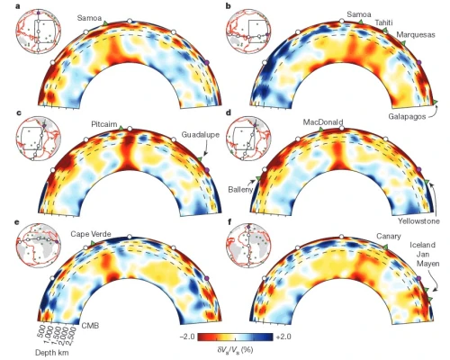
By providing visible proof of the processes that shape the planet over millions of years, this has completely changed our understanding of plate tectonics, volcanic hotspots, and deep Earth convection.
7. Environmental and urban geology
Geology has expanded into new fields in response to pressing global challenges like urbanization, climate change, and water scarcity. For instance, urban geology studies how human infrastructure interacts with underlying geological systems, which is important for earthquake resilience, metro construction, and city planning.
In order to control land use, anticipate sinkholes, and restore contaminated areas, environmental geologists are employing real-time monitoring of soil, groundwater, and rock features. Geology is currently at the forefront of sustainable development, from CO2 sequestration to the evaluation of geothermal energy.
8. Paleoclimatology and climate modeling
Predicting the future of Earth requires an understanding of its historical climates. Geologists reconstruct historical settings, some dating back hundreds of millions of years, using sediment cores, fossil assemblages, and isotope ratios. Climate models that forecast how the planet may react to continued greenhouse gas emissions and global warming are fueled by these reconstructions.
Geology is crucial to climate policy and adaptation planning because of the recent integration of climate proxies with AI and high-resolution dating, which has greatly increased the accuracy of paleoclimate models.